

INDUSTRIES WE SERVE
CONSTRUCTION
Drones offer a rapid and secure method for capturing critical site data. They can efficiently acquire real-world images, videos, thermal scans, LiDAR point clouds, and 3D maps of terrain and building sites, surpassing traditional methods in terms of speed, safety, and detail. From initial planning to project completion, drones empower general managers and project managers to meticulously track every aspect and deliver comprehensive, regular reports to clients.

CONSTRUCTION
Benefits
IMPROVED EFFICIENCY:
Streamlines data collection and optimizes project planning.
ENHANCED SAFETY:
Reduces risk to personnel and minimizes on-site accidents.
INCREASED ACCURACY:
Provides precise measurements and improves construction quality.
COST REDUCTION:
Lowers costs and identifies cost-saving opportunities.
IMPROVED COMMUNICATION:
Facilitates clear communication and promotes team collaboration.


Services
LiDAR (TERRESTRIAL AND AERIAL)
-
Precise Site Surveys with Centimeter Grade Accuracy Measurements
-
Construction Progress Monitoring
-
3D Modeling for Site Planning
-
Accurate Project Documentation
-
Pre-construction Planning and Project Tracking
-
Accurate Site Planning Using Orthomosaic Photogrammetry
-
Extensive Data Collection for Precise Survey Results
-
Aerial Surveying for Comprehensive Site Analysis
-
2-D and 3-D Orthomosaic Maps
-
Site Surveys and Elevation Data with Centimeter Grade Accuracy Measurements
-
Extensive Data Collection for Precise Survey Results
-
Accurate Site Planning and Design
-
Real-time Insights into Safety, Security, and Project Progress
-
Regularly Scheduled Live Aerial Inspections
-
Automated UAV with Drone Dock Offers Enhanced Efficiency
-
Receive Live Video Feeds and Real-time Data from the Construction Site
-
Monitor Site Activity and Conditions Remotely
-
Material Quantity Measurement of Stockpiles and Earth Movement
-
Track and Monitor Project Progress
-
Enhanced Site Safety and Security
-
Rapid Site Surveys
-
Data-Driven Decision Making with Repeatable Data Analysis
-
Comprehensive Property Assessments
-
Identify Heat Related Hazards
-
Electrical Systems Inspection
-
Thermal Temperature Mapping
-
Roof and Building Envelope Inspections for Energy Efficiency and Fault Detection
-
Enhanced Visual Communication for Project Reports
-
Efficiently Monitor Progress
-
Early Issue Detection
-
Safe, Accurate Inspections
-
Site Documentation and Time-Lapse
Deliverables
-
Live Streaming
-
Gps coordinates
-
Orthomosaic mapping
-
DTM (Digital Terrain Model)
-
Contour line map
-
Elevation maps
-
Measurements for large volumes (dirt, supply stockpiles, etc.)
-
Aerial images and video
-
Thermal images
-
Lidar Point Cloud
-
LAS
-
LAZ
-
E57
-
CSV
-
-
Drone survey report

Drones revolutionize energy infrastructure inspection, offering significant advantages over traditional methods. By swiftly traversing long-distance transmission lines, scrutinizing solar farms, detecting gas leaks, and more, drones provide invaluable data for both existing and future energy infrastructure. Moreover, drones capture multifaceted data sets, enabling in-depth analysis for current needs and long-term insights. This innovative technology enhances safety, efficiency, and the overall understanding of energy systems.

ENERGY INFRASTRUCTURE

Benefits
IMPROVED EFFICIENCY:
Streamlines inspections and optimizes maintenance.
ENHANCED SAFETY:
Reduces personnel risk and minimizes accidents.
INCREASED ACCURACY:
Provides detailed data for accurate assessments.
COST REDUCTION:
Lowers inspection costs and reduces downtime.
ENVIRONMENTAL MONITORING:
Monitors environmental impact and supports sustainability.


Deliverables
-
Live Streaming
-
Gps coordinates
-
Orthomosaic mapping
-
DTM (Digital Terrain Model)
-
Contour line map
-
Elevation maps
-
Aerial images and video
-
Thermal images
-
Lidar Point Cloud
-
LAS
-
LAZ
-
E57
-
CSV
-
-
Drone survey report

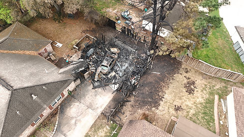
Drones significantly augment investigative capabilities, enabling rapid, accurate, and safe data collection. By preserving site integrity, drones capture detailed information, including thermal imagery, GPS coordinates, and orthomosaic maps. Additionally, real-time video feeds from drones support search and rescue operations, surveillance, and tracking during active investigations.
Benefits
ENHANCED DATA COLLECTION:
-
Quickly gather aerial imagery from large areas.
-
Capture high-resolution photos and videos of evidence.
IMPROVED SAFETY:
-
Reduce risk to personnel in hazardous environments.
-
Conduct inspections from a safe distance.
INCREASED EFFICIENCY:
-
Accelerate investigations.
-
Reduce costs associated with traditional methods.
ENHANCED EVIDENCE GATHERING:
-
Preserve incident sites without disturbing evidence.
-
Provide compelling visual evidence for legal proceedings.


Services
LiDAR (TERRESTRIAL AND AERIAL)
-
Infrastructure Inspection
-
Industrial Inspections
-
Site Mapping with Centimeter Grade Accuracy Measurements
-
Non-Destructive Incident Site Mapping
-
Utilize Visual, Thermal, and Lidar Data for Comprehensive Analysis
-
Damage Assessment
-
2-D and 3-D Orthomosaic Maps
-
Fire and Explosion Investigation
-
Incident Reconstruction
-
Insurance Investigation
-
Litigation
-
Search and Rescue
-
Fire Investigation
-
Surveillance and Tracking
-
Incident Reconstruction
-
Scene Documentation
-
Evidence Gathering
INVESTIGATIONS
Deliverables
-
Live Streaming
-
Gps coordinates
-
Orthomosaic mapping
-
DTM (Digital Terrain Model)
-
Contour line map
-
Elevation maps
-
Aerial images and video
-
Thermal images
-
Lidar Point Cloud
-
LAS
-
LAZ
-
E57
-
CSV
-
-
Drone survey report
Drone technology is revolutionizing real estate land development. From centimeter-accurate surveys and 3D orthomosaic maps to high-resolution photos, videos, and LiDAR point clouds, drones offer unparalleled precision and efficiency. Developers can leverage this data to optimize site layout, infrastructure planning, drainage design, encroachment identification, and more, ultimately leading to more informed and successful projects.


Benefits
IMPROVED EFFICIENCY:
-
Rapid site assessment and streamlined planning.
-
Efficient progress monitoring.
ENHANCED DECISION-MAKING:
-
Informed site selection and optimized design.
-
Risk mitigation.
ENHANCED MARKING & SALES:
-
Create compelling visuals and virtual tours.
-
Attract potential buyers.
COST REDUCTION:
-
Reduce survey costs and accelerate project completion.
-
Minimize errors and rework.
Services
LiDAR (TERRESTRIAL AND AERIAL)
-
View Land Contours and Existing Structures Under Heavy Vegetation
-
Precise Site Surveys and Elevation Data with Centimeter Grade Accuracy Measurements
-
Accurate Site Planning Using Orthomosaic Photogrammetry
-
Extensive Data Collection for Precise Survey Results
-
Aerial Surveying for Comprehensive Site Analysis
-
Environmental Impact Assessment
-
Site Surveys and Elevation Data with Centimeter Grade Accuracy Measurements
-
Extensive Data Collection for Precise Survey Results
-
Accurate Site Planning and Design
-
Enhanced Marketing & Sales
-
Monitoring Site Progress
-
Create Stunning Visuals to Showcase Property Features
-
Virtual Tours
-
Site Documentation and Time-Lapse

REAL ESTATE LAND DEVELOPMENT

Deliverables
-
Gps coordinates
-
Orthomosaic mapping
-
DTM (Digital Terrain Model)
-
Contour line map
-
Elevation maps
-
Measurements for large volumes (dirt, supply stockpiles, etc.)
-
Aerial images and video
-
Thermal images
-
Lidar Point Cloud
-
LAS
-
LAZ
-
E57
-
CSV
-
-
Drone survey report